


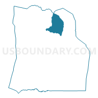
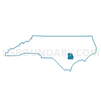
Voting District GLIS, Duplin County, North Carolina
About
Outline

Summary
| Unique Area Identifier | 639925 |
| Name | Voting District GLIS |
| County | Duplin County |
| State | North Carolina |
| Area (square miles) | 30.18 |
| Land Area (square miles) | 29.84 |
| Water Area (square miles) | 0.33 |
| % of Land Area | 98.90 |
| % of Water Area | 1.10 |
| Latitude of the Internal Point | 35.09326950 |
| Longtitude of the Internal Point | -77.87465710 |
Maps

Graphs
Select a template below for downloading or customizing gragh for Voting District GLIS, Duplin County, North Carolina


Neighbors
Neighoring Voting District (by Name) Neighboring Voting District on the Map
- Voting District 15, Wayne County, NC
- Voting District ALBE, Duplin County, NC
- Voting District KENA, Duplin County, NC
- Voting District SMCA, Duplin County, NC
- Voting District WOLF, Duplin County, NC
Top 10 Neighboring County Subdivision (by Population) Neighboring County Subdivision on the Map
- Indian Springs township, Wayne County, NC (7,790)
- Kenansville township, Duplin County, NC (5,565)
- Albertson township, Duplin County, NC (3,878)
- Wolfscrape township, Duplin County, NC (3,267)
- Glisson township, Duplin County, NC (2,718)
- Smith township, Duplin County, NC (2,517)
Top 10 Neighboring Unified School District (by Population) Neighboring Unified School District on the Map
Top 10 Neighboring State Legislative District Lower Chamber (by Population) Neighboring State Legislative District Lower Chamber on the Map
Top 10 Neighboring State Legislative District Upper Chamber (by Population) Neighboring State Legislative District Upper Chamber on the Map
Top 10 Neighboring 111th Congressional District (by Population) Neighboring 111th Congressional District on the Map
Top 10 Neighboring Census Tract (by Population) Neighboring Census Tract on the Map
- Census Tract 901, Duplin County, NC (10,062)
- Census Tract 6.02, Wayne County, NC (8,980)
- Census Tract 904, Duplin County, NC (5,962)
- Census Tract 905.01, Duplin County, NC (5,518)
Top 10 Neighboring 5-Digit ZIP Code Tabulation Area (by Population) Neighboring 5-Digit ZIP Code Tabulation Area on the Map
- 28365, NC (17,144)
- 28398, NC (8,112)
- 28572, NC (6,531)
- 28578, NC (6,363)
- 28349, NC (3,724)
- 28508, NC (2,737)